Cellular (5G/LTE) Coverage Scanner Drone
Tamimi September 30, 2022 [Professional] #drone #robots #Survey #Brazil #platform #indropilot #BVLOS #UAV #5G #Cellular #Autonomy #ground stationIntroduction
This encompasses two projects, but for the sake of convenience and due to their shared similarities, I have decided to present them together.
The first project involves scanning the cellular network using a Software-Defined Radio (SDR) equipped on a drone. This SDR scans the bands and nearby towers. The setup (SDR + Drone) was already completed in the NERDs project, which you can read more about in the linked article. Additionally, the software integration was already implemented in the platform, which you can also read more about in the Indropilot platform.
The second project shares the same goal as the first. However, in this instance, the client used a smartphone attached to the drone instead of the SDR
2021 - Scanning the cellular network using an SDR on a drone
| Project | Cellular Scan by a Drone |
|---|---|
| Company | INDROROBOTICS |
| Clients | ISED |
| Budget | -- |
| Duration | -- |
| Status | Conceptual design |
This project was initiated due to interest from several clients in utilizing drones and their high mobility to scan the sky for cellular coverage. Some clients, primarily cellular operators like Rogers, were interested in the cell coverage around the cell tower Base Transceiver Stations (BTS), as well as the 5G and LTE coverage, and the collection of other metrics. Other clients, such as ISED, were interested in detecting interference on specific radio frequencies and ensuring that cellular operators are adhering to the specific bands allocated to them.
I will refrain from going into detail about this project as it was still ongoing when I left the company, and it is better not to disclose any critical details. However, in a brief explanation, the pilot can remotely access the Software-Defined Radio (SDR) within the Indropilot platform and manually scan the bands at a specific point in space/time. Alternatively, the pilot can activate the auto-mode, and the SDR will scan and collect all predefined metrics throughout the entire flight.
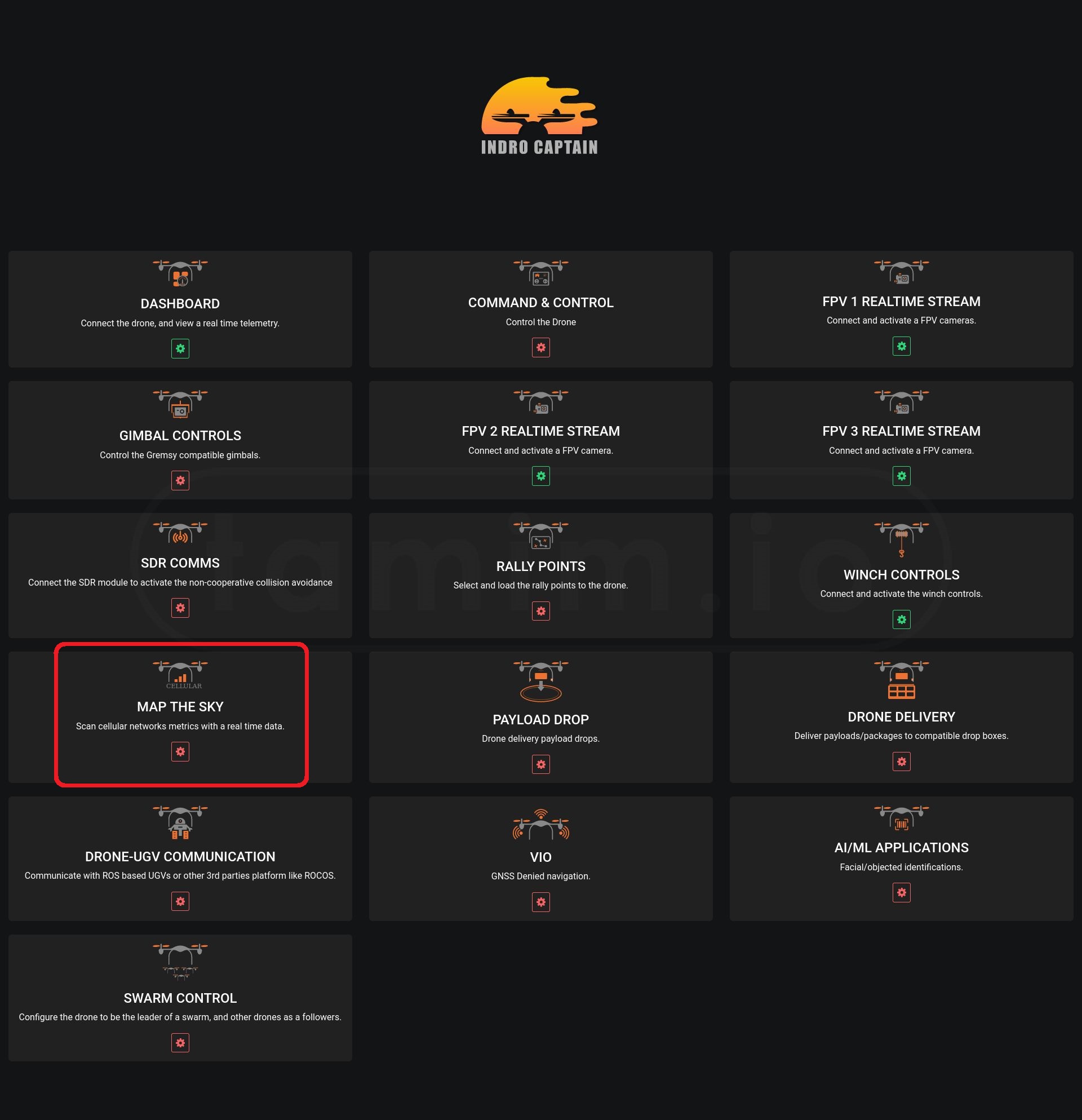
Img1: Map the sky module in the platform (Indropilot)
2022 - Scanning the cellular network using a phone on a drone
| Project | Cellular Scan by a Drone/phone |
|---|---|
| Company | INDROROBOTICS |
| Clients | ClearSky |
| Budget | -- |
| Duration | -- |
| Status | Successfully delivered |
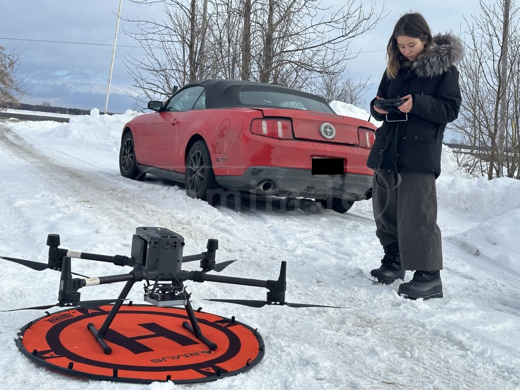
Img2: My collogue Ella going through the checklist before one of the missions
Hardware
The hardware for this project was straightforward and primarily consisted of three major components:
-The Drone: The drone used was the Matrice M300, chosen for several reasons. The primary reason was its ability to hot-swap batteries, which was crucial given the limited daily time frame for flights. Additionally, the M300 is an excellent drone that can lift the payload (phone) for this mission without being excessively large, yet strong enough to maintain speed and balance in windy weather.
-The Phone: I recommended the client to acquire the SONY Xperia 1 IV1 as it supports both sub-6GHz and mmWave for the bands in question, in addition to LTE. We also used a NOKIA phone (not a commercial model) to scan the private NOKIA network in the field.
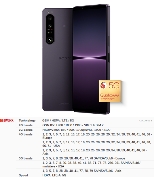
Img3: SONY Xperia 1 IV cellular and network Specs
-The Phone Case: A 3D printed case was used that fits several phone sizes that were used in these missions.
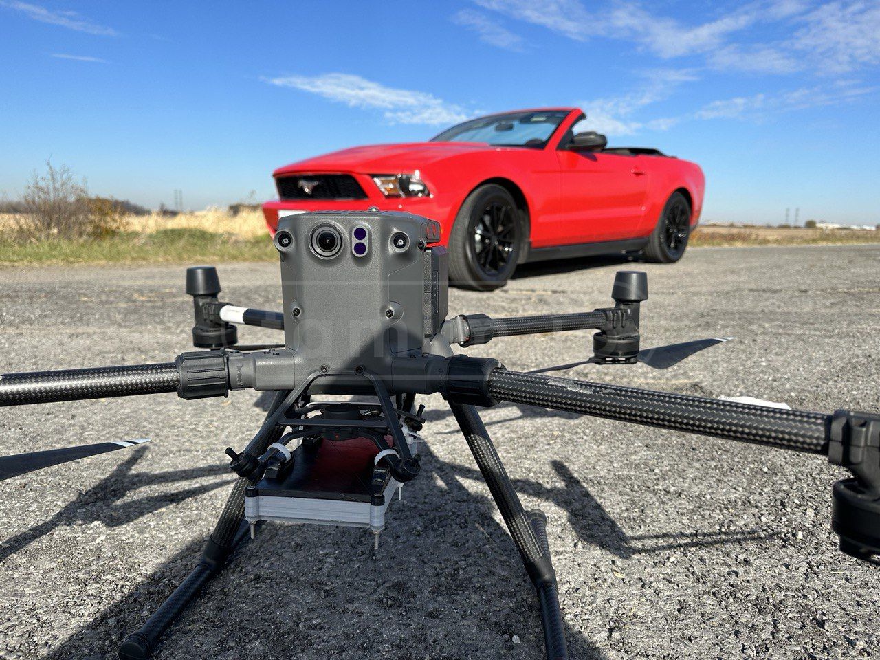
Img4: All the project hardware listed above in one picture, including the car, as seen below!
Software
The software components for this project consisted of several Android apps running in the background, collecting all the necessary metrics. The primary ones were G-NetTrack Pro2 and Network cell Info Lite3. It's important to note that these applications were used to collect the metrics, not to process and build the network visualization, as that was within the client's scope.
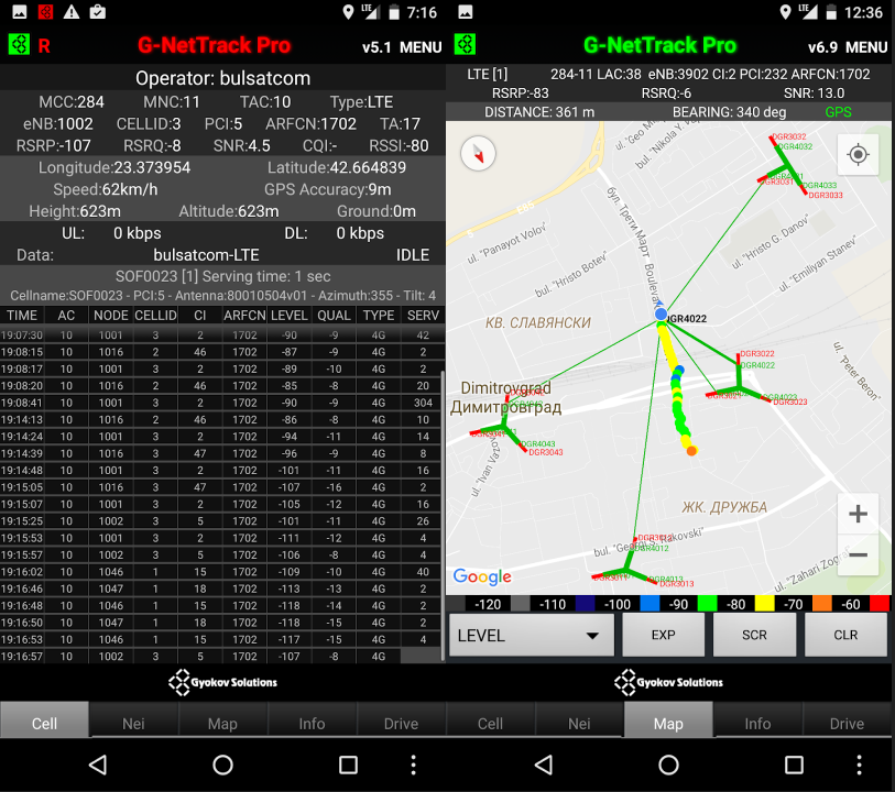
Img5: G-NetTrack Pro in action, credit to the picture from the play store
Missions
The missions were categorized based on the network, some of which were LTE while others were 5G. Some missions involved commercial cellular networks (Rogers), while others involved private ones (Nokia). Additionally, some missions were conducted on-site (at AreaXO), while others were off-site at various locations.
The general process for all these missions followed the steps below:
-
Acquiring Permissions: Necessary permissions were obtained either from Transport Canada through NAVapp, or from the property owners where the flights were conducted.
-
Scheduling: The schedule was checked and flights were aligned with the granted permissions and expected weather conditions. At times, flights had to be conducted during snowy conditions when no better days were available.
-
Equipment Checks: This involved charging the batteries, ensuring phone batteries were charged, and making sure SIM cards were ready.
-
Preflight Checks: Standard preflight checks were conducted, as any drone pilot would do before flying.
-
Postflight Checks: This included recharging all batteries, handling logistics, etc.
-
Data Unloading: The collected logs were unloaded and sent over to the client
vid1: A typical mission of collecting the metrics
Challenges
The majority of the challenges encountered in this project were operational, as listed below:
-
Schedule: The schedule needed to align with various factors, including the client's timeline, permissions, weather conditions, and the operational status of the private cellular network (Nokia).
-
Obstacles: During some flight missions, obstacles such as 40m trees interfered with the proposed flight paths. As the client requested data collection at 30m, the flight paths had to be adjusted accordingly in these areas.
-
Weather Conditions: The weather conditions were mostly suitable for flights when the missions started. However, a few weeks later, conditions changed, with windy, rainy, and snowy days. Extreme cold was not only challenging for the pilot but also affected the drone batteries and the phone itself. In some cases, the drone had to spend time overheating itself before the mission, while we stayed in the car, with me driving and my colleague piloting the drone.
-
Distance: In some missions, the altitude was 120m, and the distance from the launch point to the furthest point was as far as 2km. With obstacles in the way, we encountered RC connection issues. To counter this, I had to drive relatively close to the drone to maintain a healthy RC link and ensure the pilot kept the line of sight (LoS) required by the permissions provided.
-
Other Challenges: There were other challenges during some of the flights, such as mass migrations of birds (geese), and military personnel training at the same locations
vid2: Some missions were conducted in snowy/extreme cold conditions
vid3: The use of the car (my personal car for the record) was crucial part in some of these missions as we needed to follow the drone to maintain the line-of-sight and to keep the RC link alive.
vid4: Some of other challenges like high cross-wind (max we had was 14m/s) and bird migrations that delayed the launch of some of these flights!
Special Thanks
Special thanks goes to my colleague, Ella, who was the pilot in most of these flights (I was just the driver!), as she even continued to work despite her having Covid-19 in the last few missions!
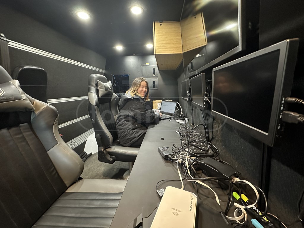
Img6: My colleague, Ella, in the portable control center doing something smart!
Note: The comment section is powered by Cactus/Matrix. If you use the official Matrix server, you are good to go. However, if you use your personal Matrix server, make sure to log in with the first button and use your own client. This is because my CSP only allows Cactus/Matrix domains to connect from this site, and most likely, your profile picture will be broken!
SONY Xperia 1 IV Specs
G-NetTrack Pro Play_Store
Network cell Info Lite Play_Store